"American Rivers has named the Mississippi River one of America’s Most Endangered Rivers of 2022, highlighting the threats that habitat destruction and pollution, combined with climate impacts, pose to millions of people across the basin. Nearly 40 percent of land in the continental United States drains into the Mississippi River, which faces urban and agricultural runoff, habitat loss, and intensifying storms. The climate crisis is compounding these threats – more frequent and severe floods carry excess sediment and pollution off the land and into the river."
"From Missouri to the Gulf of Mexico, climate change is bringing extreme weather that threatens the birds and people that call this region home. The forests, wetlands, floodplains, and barrier islands that have historically buffered communities in this region from storms and flooding are rapidly disappearing . . . To meet this challenge, Audubon has created this conservation blueprint to focus on the Lower Mississippi River region . . . Audubon will deploy natural infrastructure solutions that restore and enhance ecosystems like wetlands and floodplains, to help make communities and ecosystems more resilient to the impacts of climate change."
"Black Carp, Mylopharyngodon piceus, are raising new concerns about non-native, invasive carp species in the Lower Mississippi River. Unlike the four other non-native carp species found in the lower river, Black Carp, which can grow to 100 or more pounds, eat mussels and snails. They have pharyngeal teeth they use to crush mollusks and eat the meat. Dozens of species of freshwater mussels already are threatened by dams, sedimentation and poor water quality."
"This critical river and its tributaries — responsible for transporting more than $17 billion worth of farm products and 60 percent of all U.S. corn and soybean exports annually — has been stricken by drought since September, amid a time of global grain shortage and soaring food prices. While water levels will recover modestly this week, thanks to some upstream rain and snow, the long-term forecast remains dry . . . Radical new thinking is the only way to make sure our rivers endure. The good news is that we are already reimagining what rivers can do — and what they can be . . . If reservoirs fall to the point where they can barely be used for hydropower, they can still be used to store intermittent wind and solar energy — by recycling water that has already passed through the dam’s turbines back into its reservoir."
"The Mississippi River is remarkable because, every day, almost 20 million people in 50 cities depend on it for their drinking water. The rich soils within its vast watershed produce 90% of our country’s farm exports. However, the Mississippi River Delta and coastal Louisiana are disappearing at an astonishing rate: a football field of wetlands vanishes into open water every 100 minutes . . ."
“The ivory-bill and Louisiana are forever linked . . . The loss of this bird is particularly painful because it reflects a much larger loss of our natural heritage — old-growth bottomland hardwood forest that supported an abundance of biodiversity. When the forests disappeared, so did the ivory-bill . . . It's truly a wildlife crisis . . . The recognition that the Ivory-billed woodpecker is extinct should be yet another call to act quickly in order to prevent further loss of our wildlife and natural heritage.”
"Louisiana’s 100-year romance with the petrochemical industry has come with an undeniably steep human price tag. Tens of thousands of people, living cheek-by-jowl with belching plants along the Mississippi River, are exposed to toxic chemicals at rates that are among the highest in the United States . . . And that exposure level will almost certainly increase dramatically over the next few years, as a multibillion-dollar boom brings dozens of new and expanded plants, many in the same communities that the EPA says already face the greatest health risks.
"A historic slow-moving flood of polluted Mississippi River water loaded with chemicals, pesticides and human waste from 31 states and two Canadian provinces is draining straight into the marshes and bayous of the Gulf of Mexico — the nurseries of Arnesen’s fishing grounds — upsetting the delicate balance of salinity and destroying the fragile ecosystem in the process . . . The torrent of river water pushing into Gulf estuaries is decimating crab, oyster and shrimp populations. The brown shrimp catch this spring in Louisiana and Mississippi is already down by an estimated 80%, and oysters are completely wiped out in some of the most productive fishing grounds in the country . . .
“The U.S. Army Corps of Engineers is proposing to cut off the last connection between the Mississippi River and its natural backwater habitat in the State of Missouri by constructing a new 1,500 foot levee across the gap at the bottom of the New Madrid Floodway. This levee would prevent water from reaching 75,000 acres of floodplain habitat, eliminating the most important spawning and rearing habitat for fish in the middle Mississippi River and destroying habitat that is essential for an array of birds, waterfowl, and mammals. The U.S. Fish and Wildlife Service has repeatedly called upon the Corps to stop this project because it will cause, ‘dramatic losses of nationally significant fish and wildlife resources that cannot be mitigated,' and will, ‘greatly diminish rare and unique habitats found in southeast Missouri.'... Many outside experts agree that the adverse impacts of the project are so significant that they cannot be mitigated, and believe that the project will be the straw that breaks the camel's back for the health of this portion of the Mississippi River.”
“Beneath the surface, the oil and gas industry has carved more than 50,000 wells since the 1920s, creating pockets of air in the marsh that accelerate the land's subsidence. The industry has also incised 10,000 linear miles of pipelines, which connect the wells to processing facilities; and canals, which allow ships to enter the marsh from the sea. Over time, as seawater eats away at the roots of the adjacent marsh, the canals expand. By its own estimate, the oil and gas industry concedes that it has caused 36% of all wetlands loss in southeastern Louisiana. (The Interior Department has placed the industry's liability as low as 15% and as high as 59%.)”
"Mallards Gulls follow shrimp boats, to sup from fish churned up in the wake. Fish jump out of the water. Great blue herons. White herons. The scent of salt water mixes with swamp water. Gum trees, cypress, maple, live oak. White shell beaches. Grackles. Frigate bird. Great Egret. Elderberries ripen on shoreline bushes. Royal tern; Caspian tern, Sandwich tern. Skimmers, cousins to the water-skimming swallows of the river. A coyote, emerged from a marsh to drink from the water. Prairie: Gulf-side marsh."
“Desperate to halt the erosion of Louisiana's coast, officials there are talking about breaking Mississippi River levees south of New Orleans to restore the nourishing flow of muddy water into the state's marshes. But in a new analysis, scientists at Louisiana State University say inland dams trap so much sediment that the river no longer carries enough to halt marsh loss, especially now that global warming is speeding a rise in sea levels. As a result, the loss of thousands of additional square miles of marshland is ‘inevitable'.”
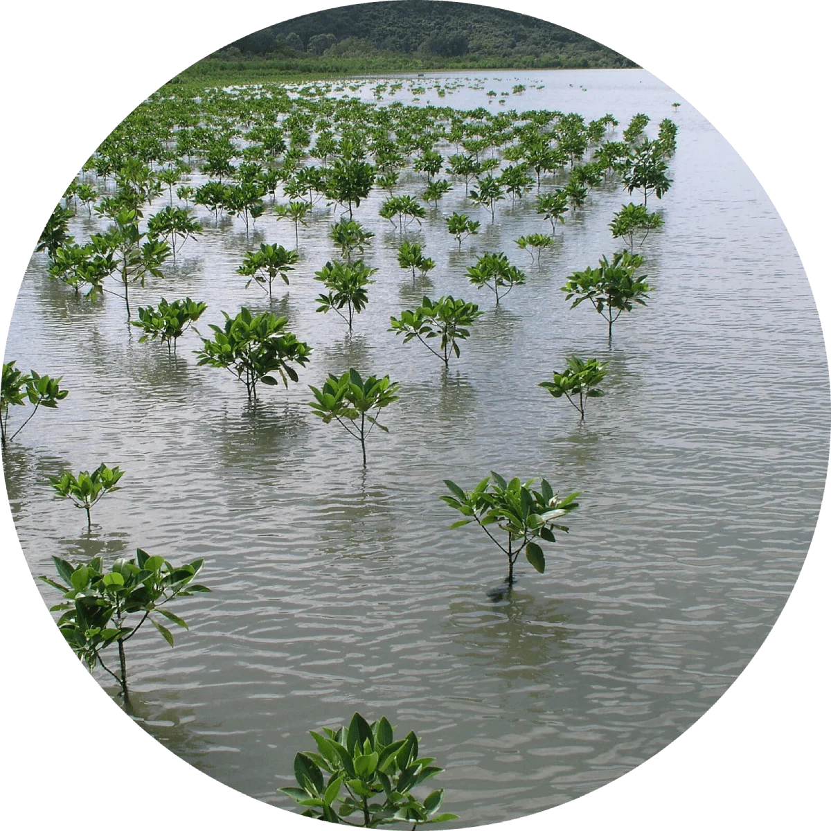
“. . . Designed to mine sediments from the Mississippi River and transport them by pipeline to rebuild eroding coastal wetlands . . . will build and restore nearly 500 acres of marsh in Lower Jefferson and Plaquemines parishes . . . The state is losing 25 to 35 square miles of wetlands each year, nearly a football field every 30 minutes. The highest rates of loss are occurring in the Barataria and Terrebonne basins at a rate of 10 and 11 square miles per year . . . The Barataria and Terrebonne basins are the two most rapidly eroding estuaries on Earth, and this erosion represents an economic and ecological crisis . . ."
“Groups in nine states petitioned the federal government in July to set and enforce pollution standards in the Mississippi River Basin and the Gulf of Mexico. The petition to the US Environmental Protection Agency followed an announcement that the dead zone in the Gulf of Mexico is the second largest to date at 8,000 square miles. The dead zone is an area of water where oxygen levels are too low to support marine life, caused by nitrogen and phosphorus pollution that flows largely from fertilizer runoff into the Mississippi, and then into the gulf. Organizations from states bordering the Mississippi River - Illinois, Iowa, Kentucky, Louisiana, Minnesota, Mississippi, Missouri, Tennessee and Wisconsin - said the EPA has dropped the ball in enforcing a 1998 rule, which required states to set standards for pollution in the Mississippi by 2003.”


Learn about Maya Lin’s fifth and final memorial: a multi-platform science based artwork that presents an ecological history of our world - past, present, and future.

Discover ecological histories and stories of former abundance, loss, and recovery on the map of memory.
Learn how we can reduce our emissions and protect and restore species and habitats – around the world.

See how art can help us rethink the problems we face, and give us hope that each one of us can make a difference.

Help make a global memorial something personal and close to home. Share your stories of the natural world.