
Ahaggar National Park, Saharan refuge
1987 CE • Central Sahara
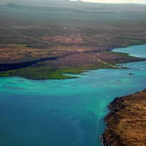
"Algeria's Ahaggar National Park covers an area of approximately 450,000 square kilometers in the Saharan Algeria Region in the extreme south of the country . . . The Ahaggar Mountains, also known as the Hoggar, dominate the park, with the highest peak being Mount Tahat, measuring 3,003 meters above sea level . . . The Ahaggar Mountain range consists mainly of jagged volcanic rock, and rainfall in the area is sporadic. Nevertheless, the biodiversity in the area is excellent, with a number of animal species that have died off in other parts of the Sahara still being found in the Ahaggar National Park. This is thought to be due to the fact that the climate in the park is less extreme than that experienced in most other areas of the Sahara. The park forms part of the West Saharan montane xeric woodlands – an ecoregion of isolated refuges where plants and animals survive the otherwise harsh conditions of the Saharan desert. This ecoregion extends across the Tassili-n-Ajjer, Ahaggar and Air massifs in Saharan Algeria."
"Ahaggar National Park, Saharan Algeria Region, Algeria," Algeria.com.
Image: Mohammed Amri, CC BY-SA 4.0, via Wikimedia Commons

Learn about Maya Lin’s fifth and final memorial: a multi-platform science based artwork that presents an ecological history of our world - past, present, and future.

Discover ecological histories and stories of former abundance, loss, and recovery on the map of memory.
Learn how we can reduce our emissions and protect and restore species and habitats – around the world.

See how art can help us rethink the problems we face, and give us hope that each one of us can make a difference.

Help make a global memorial something personal and close to home. Share your stories of the natural world.