
Gatun Lake and the Panama Canal
1904 CE - 1913 CE • Gatun Lake, Panama
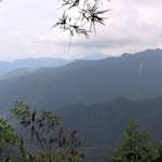
"The construction of the canal, with the necessary excavation of vast quantities of earth and its deposit at distant places, modified both the land and its plant covering. The scars left by this engineering feat are now almost obliterated, as is always true of humid tropical regions where exposed earth is soon hid under a luxuriant growth of plants. Work about the several military posts also has had a considerable effect upon plant life. Extensive low tracts have been cleared and either leveled or filled, to provide drill grounds and aviation fields; while even the remaining swamps have been ditched in order to control mosquitoes. In the forests that survive many trees have been cut to supply lumber and charcoal. There can be little land close to the canal whose vegetation has not been changed in some respect." With the completion of the Panama Canal in 1913, 164 square miles of montane tropical forest in the Chagres Valley was flooded to create the Gatun Lake. As the area filled up with water, it introduced tall grasses and water hyacinth, completely submerging the riparian landscape that once was. Today, the lake is known as a major route for oceangoing ships and its surrounding lush rainforest. Nestled in the middle of the lake is the Barro Colorado Island, one of the most intensively studied tropical forests in the world.
Quote: Paul Carpenter Standley, Flora of the Panama Canal Zone (Washington, D.C.: U.S. Government Printing Office, 1928), 10. Ashley Carse, ""Like a Work of Nature": Revisiting the Panama Canal's Environmental History at Gatun Lake," Environmental History 21, no. 2 (April 2016), 233. Christina Riehl, "Humboldt, the Panama Canal, and Barro Colorado Island," Ecology & Evolution, September 18, 2019.
Image: Detroit Publishing Co., Copyright Claimant, and Publisher Detroit Publishing Co. Gatun spillway, Panama Canal, Panama Gatun Lake Panama Canal, Photograph.


Learn about Maya Lin’s fifth and final memorial: a multi-platform science based artwork that presents an ecological history of our world - past, present, and future.
Discover ecological histories and stories of former abundance, loss, and recovery on the map of memory.
Learn how we can reduce our emissions and protect and restore species and habitats – around the world.

See how art can help us rethink the problems we face, and give us hope that each one of us can make a difference.

Help make a global memorial something personal and close to home. Share your stories of the natural world.